
Project Information
Objectives of ViWa
The ViWA research theme finds itself in the center of the water-food-energy nexus. Its nature is at the same time local and global. It therefore calls for a transdisciplinary research approach, which integrates methodologies and knowledge from different science disciplines, new global data sources, new global modeling approaches and the expertise of stakeholders from international administrative entities and companies, which share the same local and at the same time global view in the issue.
ViWA aims at developing and using a global, high-spatial and -temporal resolution, remote sensing based management and monitoring system for the efficiency and sustainability of water use in agriculture and competing sectors.
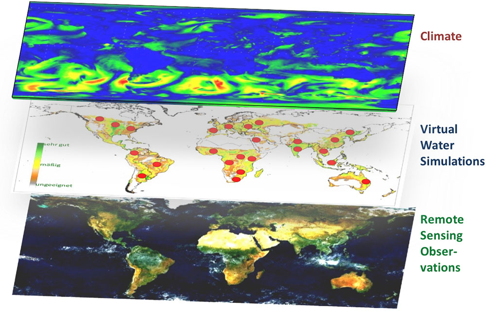
Fig.1: The global remote sensing based monitoring approach to green and blue water flows, water use efficiency and agricultural yield. Global climate data is dynamically downscaled and drives an ensemble of high resolution agro-hydrological model runs at selected test sites. In order to get global and actual data on water use their dynamic growth curves are compared with high resolution COPERNICUS Sentinel remote sensing data to determine green and blue water flows, water use efficiency and agricultural yield on a field basis on the test sites and to scale them up to global cropland area..
This enables to transparently and neutrally assess the progress in achieving water-related SDGs through more efficient use of water. The monitored high resolution data allows ViWa to consider both the “global” and the “local” in developing, formulating and analyzing trade-offs of practice-relevant solution options for a more sustainable and efficient use of water resources including a more environment-friendly trade with virtual water. To achieve its goals the project aims at the following targets:
target 1
Identify and quantify the current use of scarce water resources, the water use efficiency and the agricultural yields on an annual and global level and with high spatial and temporal resolution through a new combined monitoring and modeling approach based on Copernicus satellite remote sensing data.
target 2
Assess and evaluate the economic consequences and (in-)efficiency of the current water use and water allocation, including trade in virtual water for agriculture, industry and water management based on the monitored data.
target 3
Investigate consequences of moving towards a sustainable and efficient water use for the regional welfare of water rich and water poor countries both with respect to locally sustainable water use as with respect to global virtual water trade.
target 4
Assess the vulnerability of agriculture and ecosystems to climate variability with special emphasis on water availability.
target 5
Identify regional hot-spots of unsustainable water use in order to describe institutional obstacles for a sustainable and efficient water use.
target 6
Identify trade-offs between the commercial water use and protection of ecosystem services.
target 7
Develop solution options for sustainable water management with the help of scenarios and their trade-offs investigated for selected use-cases.